Get excited about the other TOD
Trail-Oriented Development is wildly successful in a whole bunch of places for a whole bunch of reasons.
There’s an old timey dad joke: Wherever you go, there you are.
In Atlanta, GA, I imagine the joke is Wherever you go, there you are in traffic.
The city is known for its epic sprawl and congestion. Mobility misery. It’s just assumed that you’ve got to hop in a car for any and every trip. But while they still deserve ridicule for terrible land use and transportation decisions, there’s something worth celebrating.
Georgia’s Favorite Trail-Oriented Development
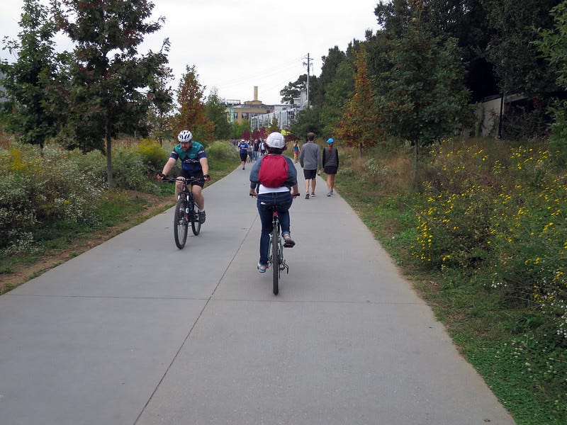
Atlanta (Atlanta!) is benefiting from an incredible regional trail. The BeltLine is a 22-mile loop of multi-use trails, parks, and eventually light-rail.
This isn’t some gimmicky trail to nowhere—the BeltLine is an economic and social powerhouse and a great example of Trail Oriented Development. It’s probably the most successful rail-to-trail story in the US, and I don’t want you to forget it’s in Atlanta. Rejoice that one of the most famous faces of sprawly Motordom can find ways to liberate people from their cars.
The BeltLine is still growing, but here are some of the highlights to date.
Money, jobs, and more money
Properties along the BeltLine have increased in value by about 50%.
The BeltLine has generated approximately 50,000 permanent jobs and 48,000 construction jobs.
The project has attracted over $8 billion in private investment. This influx of capital has spurred the development of new businesses, restaurants, and retail stores along the trail, creating a vibrant, pedestrian-friendly atmosphere. Pictures of the BeltLine look so good, you’d think they were just renderings of what might happen one day.
Abundant housing, abundant jobs, abundant shopping, abundant access:
The areas around the BeltLine have experienced significant residential growth. New apartment complexes and townhomes have sprung up along the trail, drawing residents who value easy access to recreational spaces and amenities.
Businesses located along the BeltLine have seen increased foot traffic. Restaurants, retail stores, and service providers benefit from the steady stream of pedestrians and cyclists, creating the type of lively community atmosphere people hope for.
Well-lit pathways, marked crosswalks, and pedestrian signals have been installed all over the place.
The BeltLine connects 45 neighborhoods, numerous parks, schools, and commercial districts. It also integrates with MARTA, Atlanta's primary public transit system. The walk/roll/bike/transit connectivity reduces reliance on cars.
Healthier surroundings, healthier bodies
The project added 1,300 acres of new greenspace and restored 700 acres of existing parkland.
People are loving these green spaces for exercise, hanging out with friends, or just enjoying nature. They’ve been tracking better health outcomes—lower rates of obesity, diabetes, and cardiovascular diseases among residents who say they use the BeltLine network regularly.
The trail is still growing
The vision for the BeltLine includes comprehensive light rail transit options that will integrate with existing MARTA networks. Last year, they started planning light rail alignment and station locations for the remaining segments.
I’m telling you, it’s worth spending some time on the internet looking at examples of Trail Oriented Development. The South grew a ton during the Automobile Age, which is a big reason it’s so sprawly compared to the Northeast and Mid-Atlantic. So it’s particularly encouraging (and worth spotlighting) the Trail Oriented Development in that area of the US. Here’s a list to get you started:
Swamp Rabbit Trail in South Carolina
Cross-Charlotte Trail in North Carolina
Katy Trail in Texas
Lafitte Greenway in Louisiana
Now stop reading and go visit a trail.


#buildthetrails!
Whenever cities build trails, developers follow the new housing, and businesses follow with new amenities.
Look at the BeltLine, 606 "Bloomingdale Trail", the High Line, and the Strand. These paths are immensely popular and great for transit, exercise, and social well-bring.
While old rails are not always available, virtually every city has a surplus of streets designed for cars, many with two parking lanes and two vehicles lanes, with the houses often served by alleys on both sides.
Cities could convert just a handful of 2 mile long neighborhood streets into trails. This would spur housing and business investment. It would improve health and safety.
The key challenge is convincing people who live on the street they can live there without vehicle access in front. The second challenge is handling all of the cross-street crossings. This can be done with street narrowing and visible crosswalks. Incremental upgrades can include pedestrian/cyclist activated signal synchronization for no-wait signal priority.
#buildthetrails #bettercitiesproject
Bloomington-Normal has the Constitution Trail as a back-bone non-car travel. Goes straight through the university too.
https://www.constitutiontrail.org/